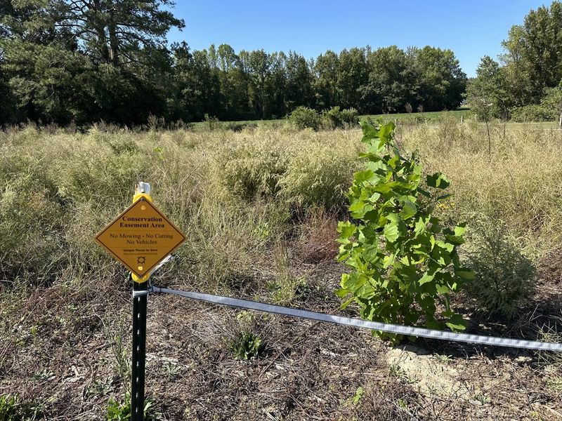
A Conservation Easement Area sign beside a young planted sycamore in a field of tall grasses at Brooks Swamp

Credit type · sold in pounds of nitrogen or phosphorus

Nutrient Offset Credits

Per-pound nitrogen and phosphorus credits from approved restoration sites, for developments in the Neuse River and Jordan Lake watersheds that cannot meet their stormwater nutrient targets on site alone.

Neuse RiverJordan Lake

What nutrient offset credits are

North Carolina’s nutrient-sensitive watersheds — the Neuse River, Tar-Pamlico River, Falls Lake and Jordan Lake — have rules that cap the nitrogen (and in Jordan Lake and Falls Lake, phosphorus) that new development may export in its stormwater. The targets are expressed in pounds per acre per year. Projects meet them first with on-site stormwater control measures such as bioretention, wet ponds and disconnected impervious surfaces. When those measures cannot bring a site all the way to the target, the rules allow the remaining load to be offset by paying for an equivalent, permanent nutrient reduction somewhere else in the same watershed.

A nutrient offset credit is that reduction, quantified in pounds and approved by the NC Division of Water Resources (DWR). Buyers can purchase credits from the state’s in-lieu fee program run by the Division of Mitigation Services (DMS), or from a private provider like RestorEcology whose projects DWR has approved.

Who needs them

  • Developers and property owners whose site plans in the Neuse or Jordan Lake watersheds exceed the nitrogen or phosphorus loading target after on-site treatment.
  • Civil engineers and stormwater consultants preparing nutrient calculations and offset documentation for local-government plan approval.
  • Municipalities and utilities, which in some cases may use nutrient offsets toward wastewater or stormwater program obligations.

Your local government’s stormwater reviewer or DWR will tell you how many pounds you must offset. We sell exactly that quantity.

How our credits are generated

RestorEcology partners with landowners to take cropland along streams and ditches out of production and plant it with native hardwoods: oaks, bald cypress, sycamore, poplar, persimmon and more. Forested buffers filter runoff, take up nutrients and stabilize banks. DWR reviews the plan, the planting and years of monitoring data, then approves a specific number of pounds of nitrogen (and phosphorus in Jordan Lake) that the site is credited with removing. A recorded conservation easement and an endowed long-term steward guarantee the buffer stays forested in perpetuity, which is what makes the reduction permanent.

Where you can use them

Offsets must be used in the watershed where they were generated:

  • Neuse River basin (HUC 03020201, excluding the Falls Lake watershed): nitrogen credits from our Brooks Swamp, Green Heron and Sand Hill sites in Wayne County.
  • Jordan Lake, Upper New Hope arm: nitrogen and phosphorus credits from Bandit Farms in Orange County. Jordan Lake rules require credits from the same sub-watershed as the impact.

Check an address on our service-area map.

How to buy

  1. Send a credit inquiry with your project location and pounds needed.
  2. We email a quote with pricing and availability.
  3. Confirm, and we send an invoice.
  4. After payment, we issue a Credit Transfer Certificate for your permit file and a copy of the DWR-approved ledger showing the transaction.

Why buy from a private provider

Private-bank credits are typically available immediately and priced competitively with the state program, and they come from a specific, approved site you can visit. In some watersheds the state’s in-lieu fee program has suspended new applications, leaving private providers as the only option. Either way, a DWR-approved credit satisfies the rule; the difference is speed, price and knowing exactly where your offset came from.

Source projects

Sites generating nutrient offset credits

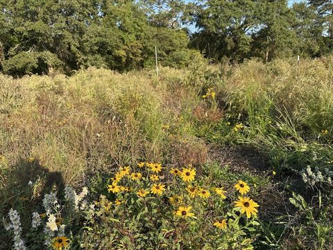
Black-eyed Susans and native grasses filling a restored field at Brooks Swamp, with mature hardwoods behind

Neuse River · Wayne County, NC · 11 acres

Brooks Swamp Mitigation Site

11 acres of former cropland along two Brooks Swamp tributaries, planted with native hardwoods in 2024. Nitrogen and Neuse buffer credits available now.

Nitrogen availableRiparian buffer available
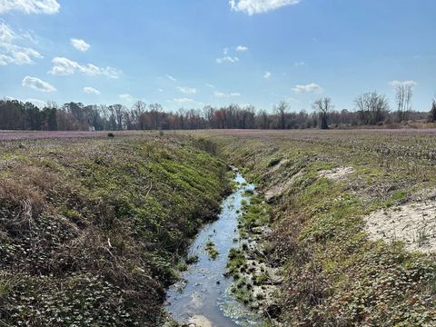
An agricultural drainage ditch running between cropland fields at the Green Heron site before restoration, with purple henbit blooming

Neuse River · Wayne County, NC · 35 acres

Green Heron Mitigation Site

35 acres on Edwards Branch and four tributary streams near Goldsboro. Existing wooded buffers preserved, cropland planted in native hardwoods. Nitrogen and buffer credits available.

Nitrogen availableRiparian buffer available
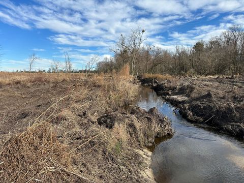
A tributary of Horse Branch flowing through cleared former cropland at the Sand Hill site in winter, before planting

Neuse River · Wayne County, NC · 33 acres

Sand Hill Mitigation Site

33 acres on Horse Branch and a tributary near Grantham. Hardwood swamp preserved, cropland planted with native hardwoods. Nitrogen and Neuse buffer credits available.

Nitrogen availableRiparian buffer available
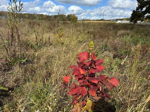
A young planted oak seedling with red autumn leaves growing in a restored meadow at Bandit Farms, with the winery buildings in the distance

Jordan Lake · Orange County, NC · 17 acres

Bandit Farms Mitigation Site

17+ acres of former cropland at a winery in the Morgan Creek headwaters, planted with native hardwoods. Buffer, nitrogen and phosphorus credits for the Upper New Hope arm of Jordan Lake.

Riparian buffer availableNitrogen availablePhosphorus available

Common questions

Buying credits from RestorEcology

How do I buy credits from RestorEcology?

Send us a credit inquiry with your project location, the credit type and the quantity your permit requires. We reply by email with a quote showing pricing and availability. Once you confirm, we issue an invoice. When payment is received (usually by check), we send a Credit Transfer Certificate that serves as your receipt and as documentation for the regulatory agency, along with a copy of the official credit ledger recording the sale.

How quickly can I get a Credit Transfer Certificate?

Quotes usually go out within a business day of your inquiry. The certificate is issued as soon as payment clears, so the overall timeline mostly depends on your side: how quickly you confirm the quote and send payment. If you have a permit deadline, tell us in your inquiry and we will work to it.

How do I know which service area my project is in?

Credits must be used in the watershed where they were generated. Our Neuse credits serve the Neuse River basin below Falls Lake Dam (HUC 03020201, excluding the Falls Lake watershed); our Jordan Lake credits serve the Upper New Hope arm; and our Tennessee stream credits serve the Hiwassee watershed with Watts Bar Lake and Middle Tennessee–Chickamauga as secondary areas. The fastest check is to type your project address into the service-area map. If you’re still unsure, send us the address and we’ll confirm.

What types of credits do you sell?

Three kinds: nutrient offset credits in pounds of nitrogen (Neuse and Jordan Lake) and phosphorus (Jordan Lake); riparian buffer credits in square feet (Neuse and Jordan Lake); and stream mitigation credits quantified with the Tennessee SQT (Porterhouse Valley Mitigation Bank).

See all frequently asked questions →

Need nutrient offset credits?

Send us your project location and the quantity your permit requires. We reply by email with pricing and availability.